Main points
- An international team of researchers accidentally discovered a new island near Antarctica, initially mistaking it for a dirty iceberg.
- The island is 130 meters long and 50 meters wide. It now needs to be officially registered and named in order to appear on nautical charts.

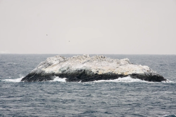
An island in the Weddell Sea that has not yet been charted / Alfred Wegener Institute / Christian Haas
During a storm in the Weddell Sea, the crew of the icebreaker Polarstern sought shelter off the coast of Joinville Island. However, instead of a safe harbor, the researchers saw a strange object that had been hidden from satellites and navigation systems for decades, disguised as an ordinary polluted piece of ice.
What secrets did the “danger zone” hide on nautical charts?
The 93-member international team of researchers, led by the Alfred Wegener Institute (AWI), had no intention of making such a major discovery. Their mission, which began on February 8, 2026, was to study the outflow of water and ice from the Larsen Ice Shelf and analyze the rapid melting of sea ice in recent years. However, bad weather forced the ship to change course, which led to an unexpected result, writes the Daily Mail.
Underwater mapping specialist Simon Droitter noticed that an area of unknown navigational risk had been marked on their path. After checking all the available data in the bathymetry laboratory and returning to the bridge, he looked out the window and saw an object that was initially mistaken for a very dirty iceberg. Only upon closer inspection did it become clear that it was not ice but real rock. The team decided to get closer, and with each meter it became more obvious: they were looking at an unknown island.
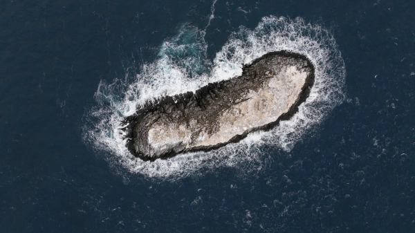
The navigators carefully approached the Polarstern to a distance of about 150 meters, constantly monitoring the depth under the keel, which was at least 50 meters. For a detailed study, a drone was used, which helped to conduct photogrammetric analysis and create an elevation model.
The island was found to be about 130 meters long and 50 meters wide, with its highest point rising 16 meters above the water, the AWI website said. It was slightly longer than the icebreaker itself and almost as long as the Great Pyramid of Giza.
Unnamed island in the Weddell Sea / Photo Alfred Wegener Institute / Simon Dreutter
The reason the island went unnoticed for so long is because of its thick ice cover. In satellite images, it was virtually indistinguishable from the numerous icebergs drifting nearby.
Interestingly, on some navigational charts, this place was still marked as a danger zone, but its actual location deviated from the coordinates in the documents by approximately 1.82 kilometers, or one nautical mile.
Unnamed island in the Weddell Sea / Photo Alfred Wegener Institute / Christian Haas
The island needs a name
Now the scientists face the task of officially registering the discovery. Boris Dorschel-Ger, head of the AWI bathymetry department, notes that the island needs to be named before it can be added to international nautical charts, writes IFLScience.
Social media users have already suggested several options: from the ironic “Iceberg” to the fabulous “Lummerland”. Official mapping is critical for navigation safety and to replenish the database of the geological environment of the Weddell Sea.